

Peggy Smith-Hake's
"Window to the Past"

The History of Miller County
By Kelly Warman-Stallings
(From the book entitled, The Ghost Towns of Central Missouri, © 1992)

Miller County, mostly mountainous in the southern region and with prairies in the north, was originally a vast forest prior to the Louisana Purchase. The land became St. Louis County in 1813 when Missouri declared her 'territorial rights'. In 1816, St. Louis retained control of most of the present-day county except for the northern tip which Howard County took claim over; by 1819, Franklin County was created and took over most of the land.
By 1830, north of the Osage River belonged to Cole County and south of the river was a part of Crawford County. Miller County claimed all right to the present-day boundaries on February 6, 1837.
The first people in the land were the proud Osage Indians, a tribe of the Siouan race. This tall race of men, some measuring almost 7 feet tall, was called the Wazhazhe meaning, "War People". For many years these proud Indian tribes roamed the vast hillsides undisturbed and made their homes among the forests along the Osage River and its tributaries. About 1822, an Indian village was recorded as existing in Richwoods towhship, north of present-day Iberia near the Barren Fork Creek.
In the early 1800s, the first whites to enter the land were mostly from Kentucky, Tennessee, and the Carolinas. Some of the names of record were: Day, Lindley, Miller, West and Wilson.
However, about 1719 the first known white man to explore the Osage River region was a French explorer named Charles Claude DuTisne (pictured on the right).
Zebulon Pike also traced along the Osage River passing through Miller County in his great quest for passage west and discovered the magnificent mountain in the Colorado Rockies which was named in his honor, Pike's Peak.

Situated in the central part of the state, Miller County was named for John Miller, Missouri's 4th governor (1825-1834). John Miller served in the War of 1812 under the leadershipof General William Henry Harrison who later became America's ninth president in 1841. The Miller family was an early and prominent pioneer family who came into central Missouri about 1815 and was very instrumental in the organization of the county in 1837.
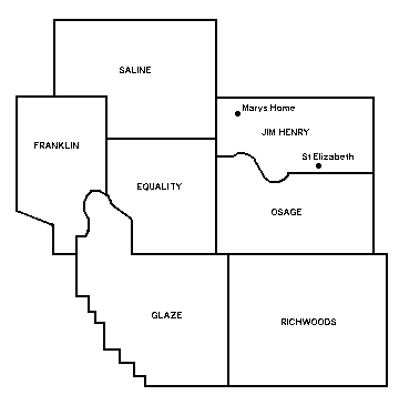
When the county was newly formed, four townships were established: Equality, Osage, Richwoods and Saline. Three more townships were added later: Franklin, Jim Henry and Auglaize/Glaize.
The first officials of the county were appointed by then Governor of Missouri, Lilburn Boggs. The date was May 1, 1837 and those appointed included John Francis, Presiding Judge; Edmund Wilkes and Steven Blevans, Associate Judges; William N. Harrison, Sheriff and Collector; James P. Harrison, Clerk of the County Court; William H. Pulliam, Assessor; Marquis Chalmes, Surveyor.
The first post office was located at Tuscumbia (1837) and the first marriage license was issued to Sims Brockman and Rachel Gartin on February 27, 1837. There were fourteen schools (mostly one-room log cabins) in 1840 and by 1931, the county had a staggering 82 schoolhouses. The population of Miller County in 1840 was 2,282; by the year 1904 the population had increased to 15,187. Also, at the turn of the century, the county had a total of 24 towns and villages and eight newspapers in circulation: Tuscumbia Autogram; Osage Valley Western Preacher; C.M.A. companion; Olean News; Eldon Advertiser; The Blue Ribbon; Eldon Eagle; and, the Iberia Impetus.

