

Peggy Smith-Hake's
"Window to the Past"

Miller County Landmarks
By Kelly Warman-Stallings
(Published on the "Window to the Past" website 18 June 2022)
Throughout Miller County, Missouri there are many various places and structures that are considered historic landmarks in the 21st century. The following is a list of places selected for the WTTP website.
Bagnell Dam
Construction on the Bagnell Dam was originally started in 1924 by two businessmen from Kansas City - Ralph Street and Walter Cravens - who arranged the financial backing and formed the Missouri Hydro-Electric Power Company. Roads, housing, railroad lines and other facilities were soon built to support the construction of a dam near the small settlement of Bagnell. When financial difficulties arose in 1926, building of the dam was halted. In 1929, Union Electric Company of St. Louis (today known as Ameren Missouri) purchased the project and construction resumed on August 6 of that same year. By 1930, when the Great Depression was sweeping across the country, the Bagnell Dam became the only major construction project in the country and attracted more than 20,000 workers from all over the nation. Commercial operation of the Bagnell Dam began on October 16, 1931. It is interesting to note, Bagnell Dam was the largest [and the last] major dam in the United States to be built with private investment. For further information, please visit: Bagnell Dam | Ameren Missouri

Bagnell Dam - 2022
Photo Credit: KWS

Construction of Bagnell Dam - c/1929
Photo Credit: Miller County Historical Society

Osage River at Bagnell Dam in Miller County - 2022
Photo Credit: KWS
Bray's Mill
Bray's Mill is located a few miles northeast of Iberia in Richwoods Township and was once a thriving industrial business in the old settlement of Brays. This historic mill was built in 1889 and is the last mill of its kind left in Miller County today. There had been an operating mill at Brays since the 1850s. The first mill - built in the early 1850s - was a water mill that was used for grinding and crushing various grains; it is unknown what happened to the first mill, but Bray's Mill would later be built on its site. The second mill, which sat near the first mill, was a woolen mill - built c/1870s - and was destroyed by a fire sometime after 1890. Today, Bray's Mill, which was a roller mill, sits alone in this once-busy village that contained an ice plant, school and hotel (which are gone today), as well as a general store and blacksmith shop that are just dilapidated memories in 2022. For further information, please visit: Brays Mill

Bray's Mill - 2018
Photo Credit: KWS

Old general store at Brays - 2022
Photo Credit: KWS

Old blacksmith shop at Brays - 2022
Photo Credit: KWS
Catholic Churches
The first Catholic Church in the county was established in 1870 at Old St. Elizabeth, once located along the south side of the Osage River, about 3 miles northeast of present-day St. Elizabeth. This pioneer church was originally intended for all Catholic families in the region, both north and south of the Osage River in Miller County. In 1883, a Catholic church (Our Lady of the Snows) was built at Mary's Home, which was located about 3.5 miles north of the Osage River, producing the first split from the original church. Sometime between 1883-1884 the original Catholic church congregation re-located 3 miles inland when Old St. Elizabeth moved their town to its current location. A frame building was erected c/1884 and the church became known as the Parish of St. Lawrence. This framed church existed from c/1884-1907. The current church (Parish of St. Lawrence) was completed in April of 1907. In August of 1906 a third Catholic church (St. Anthony of Padua) was built at St. Anthony, bringing about another division of the original church for a final time. None of the original Catholic church buildings [of the late-1800s to early-1900s] remain in the county today. For further information, please visit: Catholic Churches - Miller County

Original Roman Catholic Church
at Old St. Elizabeth - built c/1870.
Photo Credit: Miller County Historical Society

Our Lady of the Snows at Mary's Home in 2022
Organized: 1883; Current church built: 1907
Parochial Administrator: Fr. Alexius Ekka
Photo Credit: KWS

Parish of St. Lawrence at St. Elizabeth in 2022
Organized: c/1884; Current church built: 1907
Parochial Administrator: Fr. Ignitius Nimwesiga
Photo Credit: KWS

St. Anthony of Padua at St. Anthony in 2022.
Organized: 1906; Current church built: 1955
Parochial Administrator: Fr. Ignitius Nimwesiga
Photo Credit: Jefferson City Diocese
Charcoal Kilns
The charcoals kilns, located a couple of miles south of Iberia, were built in the mid-1900s by Walter Hedges and Everett Smith. Several men were employed as woodcutters and transporters of cord wood between Iberia and Meta (Osage County). According to Peggy Smith Hake, there was "a huge amount of trees felled in the area". There were a total of ten kilns built on a hillside, east of Highway 17, when operations first began. During the 1960s a couple of the charcoal kilns exploded overnight, causing major damage. According to local legend, the wood was put into the kilns overnight to make the charcoal but it was not ventilated properly, causing the horrid explosion. It was reported that no one was injured during this accident. The charcoal kiln business ceased to exist around the early 1980s. Today, there are only three charcoal kilns still intact, but in very poor condition. The other kilns are either gone or have caved in. For further information, please visit: Iberia Charcoal Kilns

Charcoal Kilns - c/1950s
Photo Credit: Miller County Historical Society


Charcoal Kilns - 2022 Photo Credit: KWS
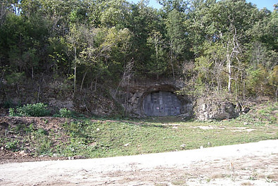
County Caves
In Miller County there are a total of 104 caves, most are well known to the locals, while other caves are unknown to the public and hidden on private property. The native Osage Indians, who discovered these caves, had many uses for these natural wonders from living quarters to burial grounds. The four most well-known caves are: Bat Cave, Stark Caverns, Wilson Cave and Wright Cave. Many legends are associated with the caves of Miller County, including meeting places and supply depots for Civil War Confederate guerillas and hideouts for the Jesse James gang. Other caves, such as Wilson Cave and Jim Henry Cave, were made into homes for their respective families. During the Prohibition of the 1930s, some of these county caves were turned into speakeasies and moonshine distilleries, equipped with liquor stills and dance floors! For further information, please visit: Missouri Caves

Bat Cave - c/late 1800s; J. R. Wells Steamboat is pictured.
Photo Credit: Miller County Historical Society
Bat Cave is located along the Osage River near the mouth of the Big Tavern Creek. It is a state-regulated cave, not open to the public, due to the grey bat community that resides there.

Wilson Cave - date unknown
Photo Credit: Miller County Historical Society
Wilson Cave is located in Osage Township and situated near the mouth of the Barren Fork of the Big Tavern Creek. The cave was named for John Wilson - an early settler in the county - who once resided there.

Stark Caverns entrance - c/1950s; Unidentified man
Photo Credit: Miller County Historical Society
Stark Caverns, also known as Mammoth Cave, is located a few miles south of Eldon. It is believed that an ancient Indian fire-pit is located at the furthest point back in the cave.
Wright Cave - c/2010
Photo Credit: Miller County Historical Society
Wright Cave is located a short distance southwest of Brumley and named for the Wright family. The cave was sealed up by the military not long after 9-11 occurred and remained inaccessible until 2015.
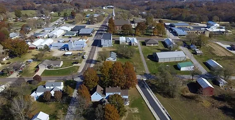
Eldon Landmarks
In the 1880s, Eldon was just a small settlement located a few miles north of Aurora Springs, which was the largest town in Miller County during that era. When the building of the railroad bypassed the larger town in favor of the small settlement, Aurora Springs was severely impacted by an economic recession. According to Peggy Smith Hake, she wrote, "By 1905, Eldon had two railroads, the Missouri Pacific, with a depot at Second & Maple Streets, and the Chicago, Rock Island, and Pacific with its depot located at the corner of Sixth & Maple Streets." The railroad played an important role in Eldon's commerce growth. Various businesses were soon added to the ever-growing settlement... from general stores and hotels to banks and barber shops. By the early 1900s, the decline of Aurora Springs became very noticeable and by the mid-1900s the once-largest town in the county ceased to exist completely. Today, Eldon is the largest town in Miller County (population: 4,416 in 2020) with very few buildings left from the 1800s era. For further information, please visit: Eldon Community


Street view of Main St. (today's Maple St.) before the roads were paved - c/1912 Photo Credit: Wesley Willis
Same street view in 2022
Photo Credit: KWS
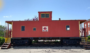
Mo-Pac Railroad caboose (c/1910s),
located on Maple St., in 2022.
Photo Credit: KWS

Historic Randles Court in 2022
Built: c/1931-33; Current Proprietors: Jeremy & Jennifer Hart
Original proprietor was Loyd Boots, who built a tavern and motel known as Boots Tavern & Boots Cottage Court. The property has been known as Randles Court since 1947 when Helen Randles took ownership. Boots Tavern would later become Randles Court Restaurant, which burned down in 2017.
Photo Credit: KWS
Grand Auglaize Bridge
The Grand Auglaize Bridge, also known as the Brumley Swinging Bridge, is a historic vernacular bridge that was built sometime between 1920-1931. The historic bridge was built by Joseph Dice of Benton County who built about 40 swinging bridges throughout Missouri during his lifetime. The original 400-foot structure was the last swinging bridge in the state to carry vehicular traffic and was permanently closed to all traffic in 2021. The grassroots organization, Save The Historical Brumley Swinging Bridge, has been instrumental in saving this bridge from destruction. The Grand Auglaize Bridge was placed on the National Registry of Historical Places on October 8, 2020. For further information, please visit: Save The Historical Brumley Swinging Bridge

West side of bridge - 2020
Photo Credit: KWS

Historic Photo - c/1950s
Photo Credit: Unknown

East side of bridge - 2022
Photo Credit: KWS
Hoecker-Henley Railroad Bridge
The Hoecker-Henley Railroad Bridge is a through-truss bridge that was built in 1903 by A. J. Tullock of Leavenworth, Kansas and American Bridge Co. of New York. Its total length is 1,385 feet and spans the Osage River between the historical communities of Hoecker (Miller County) and Henley (Cole County). The railroad bridge was constructed for the Chicago, Rock Island & Pacific Railroad and this particular rail-line - that traveled to Meta - operated from 1903 to 1979. According to Anna Mae Whittle, she wrote, "In 1960 there was a train derailment, half a dozen or more box cars were derailed, about one half mile east of Henley. There were shoes in one car and canning lids in another. I don’t know what the other cars held; it was quite a scary sight to see…the rails bent, rails up rooted, twisted metal in the wreckage." Local legend claims that the old railcars [on the Cole County side] continue to be nestled in the woods where they tumbled so long ago. In 1980, when the Chicago, Rock Island & Pacific filed bankruptcy, the ownership of the rail-line was transferred through various owners until Union Pacific Railroad sold the line to the Ameren Corp. of St. Louis (today known as Ameren Missouri), who remain the current owners. For further information, please visit: Hoecker Community

Pictured: Frederick Steamboat aiding in construction
Construction of Hoecker-Henley Bridge - c/1902
Photo Credit: Miller County Historical Society
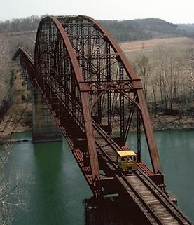
Rock Island Hoecker Bridge - 1991
Photo Credit: Howard Killiam

Old Rock Island Line bridge - date unknown
Photo Credit: waymarking.com

Bridge from Miller County side - date unknown
Photo Credit: waymarking.com
Iberia Landmarks
Iberia was first settled in the 1850s when Lenox Trading Post was established in the area. During the Civil War, Iberia was called Oakhurst (1862-1871) and also received the nickname of Rocktown. There are a few stories circulating about the name "Rocktown", but the following tales are most noted: 1) Rocks were used to throw at the Confederate soldiers when the ammunition ran out; 2) A couple of bullies in Iberia was trying to run a young black man out of town during the Civil War era, but this young black man stood his ground and picked up his own rocks to retaliate. The young black man won the fight. By the 1870s, many businesses were established, and Iberia was incorporated as a town in 1876. Many original landmark buildings have come and gone over the years, especially after the devasting fire of 1939, and today there are very few original landmark buildings left standing from the 1800s. Iberia is the second largest town in Miller County with a population of 747 in 2018. For further information, please visit: History of Iberia


Iberia street view - c/early-mid 1900s
Photo Credit: Miller County Historical Society
Same street view in 2022
Photo Credit: KWS

Old Iberia Jail in 2022
Built in 1908 by William H. Smith and his sons (Frank and Phelix). Photo Credit: KWS

Old Iberia Hotel in 1918 (left) & 2022 (right)
Built c/1885; first proprietor was E. Hendericks.
Proprietor in 1918 was Mr. Kent.
Photo Credit: Jessie (Kent) Knight (left)/KWS (right)


Masonic Lodge #410 of A.F. & A.M.
Chartered in 1871; organized in 1873; built c/1873-74.
Addition added to the building in the late 1900s.
The oldest building standing in Iberia today.
Photo Credit: KWS
American Legion (Fremont Watkins Post #105) built 1890. Originally built as the Grand Army of the Republic (G.A.R.) - Miles Carroll Post #111. After the early 1920s, the old Civil War soldiers reserved the right to access the Hall.
Photo Credit: KWS
.jpg)
Administration Building of Iberia Academy
Academy Established: 1890; Building Built: c/1922
The last building standing at the campus
of Iberia Academy in 2022.
Photo Credit: KWS

Gravesite of Elijah Dyer
Probably the oldest known gravesite in the Iberia area would be Elijah Dyer who was born in 1786 and died in 1841. He is buried outside the south entrance of Iberia Cemetery in a lone grave that has been engulfed by a densely wooded area today.
Photo Credit: Steve Yaryan (left)/Dianna (right)

World War II Tank
Located at the V.F.W. Hall - Post #6167
Photo Credit: KWS
Knotted Tree

Photo Credit: KWS
Knotted trees are fairly common throughout the world. Knots on trees, also known as "burls", are usually caused from a virus, insect infestation, fungus or an injury which interferes with the tree's growth hormones. A disruption in the tree's hormone system is what causes the abnormal growth to begin. One such tree can be found at the Bagnell Dam Scenic Overlook Park at Lake of the Ozarks. It is unknown how old the above tree is but

Photo Credit: KWS
judging by its trunk and the size of the burl it could possibly be somewhere between 150-175 years old. For further information, please visit: What Are Burls And Are They Bad For Trees
Lake of the Ozarks
Construction of Lake of the Ozarks began around the same time as Bagnell Dam's development in 1929. At the time, Bagnell Dam was truly an engineering marvel, and dignitaries from all over the country and the world came to see it. The lake was created by impounding the Osage River and three of its tributaries: Grand Auglaize Creek, Gravois Creek and Niangua River. The lake contains 54,000 acres, 1,150 miles of shoreline and spans four different Missouri counties - Benton, Camden, Miller and Morgan. While Old Linn Creek (Camden County) is reported to be the only active town affected by the creation of Lake of the Ozarks, there were many cemeteries not granted the same fate. Linn Creek moved their town, including the cemetery, to higher ground when construction began. Approximately 60 other cemeteries, spread throughout four counties, were not as fortunate. The Bagnell Dam was reportedly built atop a portion of the Crane Cemetery. At the time of its construction, Lake of the Ozarks was the largest man-made lake in America. Today, the lake is a major resort, with over 70,000 homes along the lake's shoreline, and more than 5 million tourists visit annually. For further information, please visit: Lake of the Ozarks

Old Linn Creek - c/late 1800s
Photo Credit: Unknown

Aeriel view of Lake of the Ozarks in Miller County
Photo Credit: Miller County Historical Society

Osage River, Bagnell Dam and Lake of the Ozarks - 2022
Photo Credit: Lake of the Ozark CVB
Old CRIP Rail-line Bridge
The Chicago, Rhode Island & Pacific (CRIP) rail-line bridge is located near the Miller-Osage Countyline on Old St. Thomas Road northwest of Meta. It was built as an overpass for the railroad and an underpass for vehicular traffic. The steel stringer beam bridge was built around 1903 by A. J. Tullock of Leavenworth, Kansas and American Bridge Company of New York. Also known as the Rock Island Bridge, its total length is 24.0 ft. The bridge remains intact today but has not had rail service since December of 1979. For further information, please visit: Old St. Thomas Road Overpass

Photo Credit: KWS
Olean Train Depot and the Milling Companies
The small settlement of Olean sprung up in the mid-1850s and became a booming metropolis by the late 1800s. The railroad is attributed to the boom in economy when the Jefferson City, Lebanon and Southwestern Railroad (later known as the Bagnell Branch of the Missouri Pacific Railroad) came through the area in the early 1880s. The Olean train depot was built c/1882 and was added to the National Register of Historic Places in 1993. The historic Olean Milling Company was built c/1916-17 and ceased to exist by the mid-to-late 1900s. It is interesting to note, Olean had a hard time keeping a mill building in the small town. Not a lot of information is known about the first [flour] mill, which was built by Josiah Goodman during the early 1860s. The second [flour] mill - originally known as Buckeye Mill - was built in 1881 by Joseph Gattermeir and was in operation until it was destroyed by a fire in c/1894-95. A third [flour] mill was erected by Joseph Gattermeir and Joseph Goodman in 1896 and remained in operation until 1916 when a tornado swept through the town and sabotaged the structure. The fourth mill [pictured below], which is located across the street from the railroad depot, was again built by Mr. Gattermeir not long after the tornado of 1916 and operated well into the late 1900s. A fifth and current mill [Olean Seed Company], owned and operated by Gene Enowski, has been in operation since 1986. For further information, please visit: Olean: A Former Metropolis of Miller County

Olean Train Depot in 2022
Photo Credit: KWS

Olean Milling Company in 2022
Photo Credit: KWS
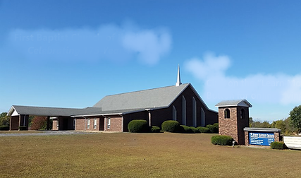
Protestant Churches
There have been many Protestant churches scattered all over the county during its existence, but it is the Methodist church that has been around the longest. Rev. Brashears was preaching to the inhabitants in 1833 as a circuit riding Methodist minister, long before Miller became a county. The first Methodist Church organized in the county was at Pleasant Mount in 1841 and was located a few miles east of Eldon. This church no longer exists. The first Baptist congregation could be found near Iberia in the early 1840s at the Big Richwoods Baptist Church (later to become known as Sulkey Baptist Church and once located where the Iberia Cemetery is today). The current Baptist church - known as Iberia First Baptist Church - was an offshoot of Sulkey Baptist and the current church was built in 1989. This is the oldest continually operating Protestant church in the county today. The oldest Christian church was located at Mt. Pleasant (Pleasant Mount) and organized in 1884. This church branched off from Salem Church, which was a Disciples of Christ denomination. The Mount Pleasant Christian Church disassembled long ago, but the building forlornly remains. The newest Protestant denomination in the county is the Nazarene church, which was organized in Eldon in 1920. This church originally congregated in the old "Universal Theater" for many years, before moving to their current building. The following Protestant denominations in Miller County have conducted religious services over the years: Assembly of God, Baptist, Christian, Church of Christ, Congregational, Jehovah Witness, Lutheran, Methodist, Nazarene and Presbyterian. For further information, please visit: Protestant Churches - Miller County

Iberia United Methodist Church
Organized: 1867; Current church built: 1904
Lay Minister: Linda Skouby
Photo Credit: KWS
Iberia First Baptist Church
Organized: 1847; Current church built: 1989
Current Pastor: Roy Bryant
Photo Credit: KWS


Pleasant Mount Christian Church
Organized: 1884; Current church built: c/1885-88
Note: No longer conducts church services
Photo Credit: KWS
Eldon Church of the Nazarene
Organized: 1920; Current church built: 1977
Current Pastor: Jerry Frye
Photo Credit: KWS
Skinner's Tomb
Located on State Highway 52, not far from the county seat, is an old grave tomb of James S. Skinner, Sr., who was born in England around 1834 and arrived in America when he was 7 years old with his mother and a younger sibling. James Skinner migrated from New York [around 1855] and arrived in Missouri in the mid-1860s, first settling in Sedalia (Pettis County). By 1870, Skinner and his wife, Lucy Folsom Skinner, were enumerated in the U.S. Census as living in Equality Township of Miller County, a few miles northwest of Tuscumbia, and there they remained for the rest of their lives. James Skinner, Sr. was a wise businessman and wealthy landowner who donated land for a school (Skinner School) to be built and created the Skinner Cemetery when his young 5-year-old daughter (Lucy) died in 1876. It was a custom of the old-timers to say, "Hoody-do, old Skinner!" when passing by his tomb. Today, not many people even know who James S. Skinner was, but ask any local in the area, and they will at least point you in the direction of his old tomb. For further information, please visit: Skinners Tomb

Historic photo of Skinner's tomb - date unknown
Photo Credit: Unknown

Skinner's tomb & Lucy's grave - 2022
Photo Credit: KWS
Spring Garden Cemetery
Located in the northern section of Miller County, not far from the Moniteau County line on State Highway AA, is one of the first cemeteries established in the county. The pioneer village of Spring Garden, considered the third settlement to be created in Miller County during the 1840s, was nearby. Between the mid-1800s until the early-1900s, Spring Garden became a prosperous settlement, with many businesses and the Miller County Institute (the first school of higher learning in the county). It is unknown when the cemetery was donated or the name of the donor, but the earliest interment is of an infant with the surname of Spaulding in 1824 (13 years before Miller became a county). The first recorded burial in this cemetery [after countyhood in 1837] is Benjamin Bond who died in 1840. Today, only the cemetery and Spring Garden Baptist Church remain in the area. For further information, please visit: Spring Garden Cemetery

Spring Garden Cemetery entrance - 2022

Cemetery donation pavilion - 2022
St. Elizabeth Landmarks
St. Elizabeth has an interesting history of being located in two separate locations. [Old] St. Elizabeth was once located on the south side of the Osage River between the late-1860s through the mid-1880s. [New] St. Elizabeth moved inland about 3 miles, southwest of its original location, around 1883-84. According to local history, another settlement called "Charlestown" was already established in this location in 1880 but was never officially platted when [Old] St. Elizabeth moved their town there. I'm sure there were many skirmishes between these two settlements to become a permanent town during the late 1800s into the 20th century, especially when [Old] St. Elizabeth was granted permission by the government to move their post office (established in 1877) from its tract of land along the river to the location of "Charlestown" (present-day St. Elizabeth). Incredibly, [New] St. Elizabeth was not incorporated as a city until June 5, 1961. Today, St. Elizabeth is the third largest town in Miller County with a population of 341 in 2018. For further information, please visit: St. Elizabeth Community


Aerial view of St. Elizabeth - c/1965
Photo Credit: Kathleen Schwartze
Schell Trading Company (2022); Built: c/1905
Original Proprietor: Idlephonse Schell
Current Owners: Dan Roling & Troy Schell
Photo Credit: KWS

Aerial view of St. Elizabeth - 2019
Photo Credit: Naden Luebbert
Kirkweg Garage in 2022 (Built: c/mid-1900s)
Original Owners: Joseph & John Kirkweg
Photo Credit: KWS

Post Office, Unidentified Building, Old Bank Building in 2022
Buildings Built: c/early 1900s
Photo Credit: KWS

M.F.A. Cooperative Association in 2022
Built: c/early 1900s
Current Manager: Rich Juergensmeyer
Photo Credit: KWS
Thong Tree
Among the many crooked trees encountered, only a few are thong trees (aka: an Indian trail marker). The casual observer often experiences difficulty in distinguishing between accidentally deformed trees and those ... purposely bent by the Osage Indians. Deformities may occur in many ways. A large tree may fall upon a sapling, pinning it down for a sufficient length of time to establish a permanent bend. Wind, sleet, snow or depredations by animals may cause accidental deformities in trees. However, such injuries leave scars which are apparent to the careful observer, and these may serve in distinguishing such trees from Indian trail markers. It is interesting to note, some thong trees will be "stunted in growth" and take longer to grow. It is unknown how many thong trees are left standing in Miller County today, but an estimated guess says, "not many". This particular tree is located along Bentown Ridge Road off Highway U. For further information, please visit: Thong Trees

Photo Credit: KWS
Tuscumbia Landmarks
Tuscumbia was established in 1837 and is the county seat of Miller County. From the early 1800s until the early 1900s it was a productive riverport town that saw many flatboats and steamboats during its heyday. The first bridge in Miller County was built at Tuscumbia in 1842 on the State Road in the Goose Bottoms, between the river and the bluff. In 1905, a public toll bridge was erected over the Osage River connecting North and South Miller County together; this was the first Joseph Dice bridge in the county. Tuscumbia has seen many businesses come and go over the years, but the county seat of government has remained steadfast. There have been three different Courthouses built over the years: first courthouse (1839-1857) cost $199 to build; second courthouse (1857-2003) cost $6,000; an addition to the [old] courthouse in 1910 was $13,800; the third [new] courthouse cost an estimated $2,500,000 in 2003. Today, there are very few buildings left standing from the 1800s. Tuscumbia is the fourth largest town in Miller County with a population of 203 in 2018. For more information, please visit: Tuscumbia


Tuscumbia toll bridge - c/1905
Photo Credit: Missouri State Archives
MO. State 17 Highway bridge - 2022
Photo Credit: KWS


The Old Courthouse. In use from 1857 to 2003. Updated photo: 2022
L to R: Front entrance (south side); back of building (north side); side of building (west side)
Photo Credit: KWS


Bank of Tuscumbia - 2022 Built c/1902; Moved to its current location c/1960s
Photo Credit: KWS
Miller County Historical Society & Museum in 2022. Housed in the original office of the Anchor Milling Co., which was built in the late 1800s. - Photo Credit: KWS
Old Sheriff Office & Jail - 2022
Built: early-1900s
Photo Credit: KWS


Old courthouse sitting atop the hill; old bank sitting below the hill in 2022.
Photo credit: KWS
The Lupardus family log cabin (left) built late 1860s and Williams family log cabin (right) built c/1850s. Both original and preserved homes are located at the Miller County Historical Society and Museum.
Photo credit: KWS

Tuscumbia Grade School - built 1938
Photo credit: KWS

Humphreys' Hospital - first full-service hospital in Miller County. Opened c/1953-54. Photo credit: KWS
Honorable Mention ... Pumpkin Patch Cave
While the "Cave Pumpkin Patch" is fairly new to Miller County, having been established in 2015 as a seasonal Autumn/Halloween attraction, it could possibly one day become a historic landmark as long as they never paint over the smiling pumpkin that graces the entrance to the cave. The cave at the pumpkin patch is called the Wright Cave, named long ago for a family in the area. It was also briefly called Arrow Point Cave when it was a show cave in the 1970’s. And today, it is referred to as the "Pumpkin Patch Cave". The "Cave Pumpkin Patch", owned and operated by Mark Beabout, also houses a venue known as "The Magic of Midnight" for weddings and various other events. For further information please visit: The Cave Pumpkin Patch


Cave entrance at Cave Pumpkin Patch - 2022
Photo credit: KWS